

Advanced Navigation has successfully demonstrated a hybrid solution for long endurance GNSS-denied navigation, proving that a software-fused inertial-centered architecture is the defining standard for autonomy.
“The world is evolving, and navigation must evolve with it. GPS is disturbingly vulnerable to challenging environments, harsh weather conditions and cyber attacks with rising threats of jamming and spoofing. The question isn’t if GPS will fail, but when. Operators need to build resilience now,” said Chris Shaw, CEO and Co-Founder, Advanced Navigation. “This hybrid solution is designed with adaptability and reliability in mind. While others focus on individual components, Advanced Navigation champions a layered, inertial-centered, multi-sensor architecture, fused together by intelligent software. This approach can be updated or modified to adapt to harsh environments and mission requirements.”
This solution is achieved by integrating a strategic-grade fibre-optic gyroscope (FOG) inertial navigation system (INS) with a new class of navigation aid: a Laser Velocity Sensor (LVS). The result is a fused hybrid architecture that delivers consistent precision and reliability in even the most challenging environments.
At the centre of every reliable navigation platform is a trusted source of truth: the INS. Advanced Navigation’s FOG INS, which is sensitive enough to detect the Earth’s rotation, provides that foundation by delivering precise attitude. Complementing this, Advanced Navigation’s LVS uses infrared lasers to measure a vehicle’s ground-relative 3D velocity with exceptional accuracy and long-term stability. Unlike conventional sensors, LVS performs reliably on both ground and airborne platforms, provided it maintains a clear line of sight to the ground or a stationary surface.
Beyond its role as a velocity aid, LVS also enhances navigation resilience by detecting GNSS spoofing. By comparing its independent velocity measurements against GNSS-derived velocity, LVS adds an extra layer of security to Assured Positioning, Navigation, and Timing (APNT) strategies.
AdNav OS Fusion utilises sophisticated algorithms to interpret and filter sensor data. The software is designed to dynamically weigh the input from each sensor, adjusting in real time based on reliability scores, environmental conditions, and operational context. This ensures continuous, high-confidence state estimation even when signals are lost, degraded, or distorted. This inertial-centered, multi-sensor approach delivers a step-change in GNSS-denied navigation performance, compared with traditional methods.
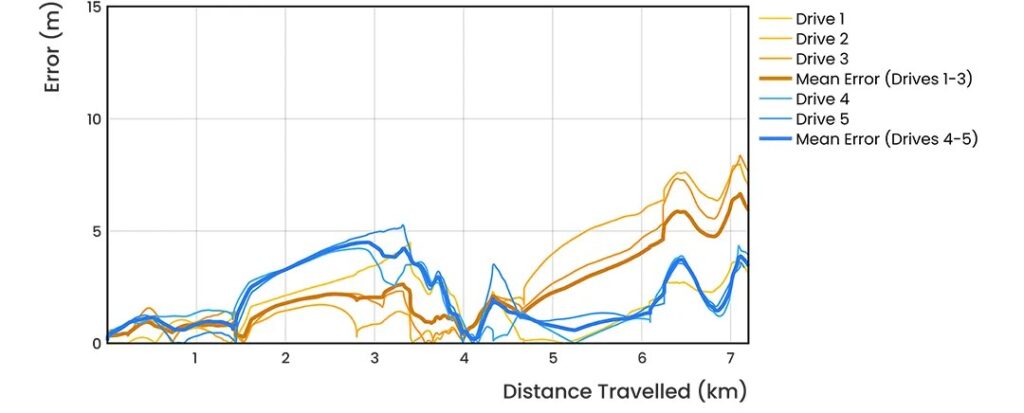
To validate the accuracy and resilience of the LVS Hybrid system, Advanced Navigation conducted a series of rigorous real-world driving tests. Across five trials, the system delivered exceptional performance with an average error per distance traveled of 0.053% compared to a GNSS reference.
At the starting point, GNSS on the INS was disabled in the state estimation process, forcing the system into dead-reckoning mode. RTK GNSS was logged separately as a reference. This approach allows for a direct comparison between the computed dead-reckoning solution and a trusted position reference.
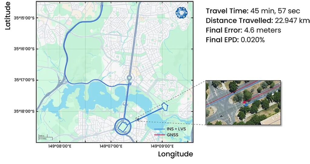
The below data shows dead-reckoning results from a 23km drive around Canberra, Australia. GNSS was not used at any point in the drive for heading or position. RTK GNSS is shown as the red line, while the hybrid system’s result is indicated in blue.

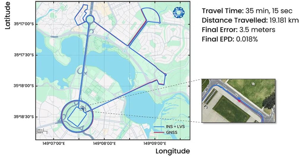
The below results are from a 19.2km drive around the Parliamentary Triangle in Canberra, Australia. GNSS was not used at any point in the drive for heading or position. RTK GNSS is shown as the red line, while the hybrid system’s result is indicated in blue.
The figure below is a zoomed section from the first test drive, showing GNSS (red) drop out as the test vehicle drove through a tunnel, which completely denied the GNSS reference measurement. The hybrid system’s result can be seen in blue, showing it did not suffer from this error.


These drives were done repeatedly, demonstrating consistent and reliable results each time.

The hybrid system was also tested on a fixed-wing aircraft combined with a tactical-grade INS, demonstrating a final error per distance traveled of 0.045% over the course of a low-altitude flight over 545km.
These overall results demonstrate the system’s impressive ability to improve navigation performance of the INS in GNSS-denied or contested scenarios.
In today’s dynamic operational environments, relying on a single sensor technology (such as GNSS or IMU) is no longer feasible. Missions increasingly take place in GNSS-denied, electromagnetically noisy, and physically complex settings where traditional systems falter.
Robust navigation demands a layered, inertial-first and multi-sensor architecture – held together by intelligent software – that can adapt and scale to meet the unique demands of each mission.
By embracing a software-defined nature, Advanced Navigation’s architecture means updates and enhancements can be deployed with minimal hardware disruption. This paradigm shift ensures resilient navigation for critical applications across defence, aerospace, robotics and autonomous systems.
There’s plenty of other editorial on our sister site, Electronic Specifier! Or you can always join in the conversation by commenting below or visiting our LinkedIn page.